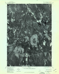
1975 Map of South Lagrange
USGS Topo · Published 1981About this map
South Lagrange serves as the primary focal point in this 1975 orthophotoquad, which utilizes aerial imagery to document the Penobscot County landscape. The settlement sits at a crossroads where rail and road corridors intersect a terrain dominated by low-lying wetlands and dense woodlands. To the south, the smaller locality of Gerry is visible, positioned near the meandering course of Dead Stream. The transition from cleared agricultural or residential plots to the expansive, darker textures of Sargent Bog and Call Bog highlights the region's complex drainage patterns. Significant water bodies such as Pickerel Pond and the branching waterways of West Branch Dead Stream define the eastern and western reaches. This survey provides a unique visual record of mid-century land use, revealing the footprint of human settlement amidst the sprawling peatlands of central Maine.
Find a feature on this map
8 named features on this map. Tap any name to fly to it.
Don’t see what you’re looking for? This feature index may not catch every label — zoom into the map to look around manually.
Map Details
Editions of this 1975 South Lagrange Map
This is the sole edition of this map. No revisions or reprints were ever made.
Other maps of this area

1902 · Orono
USGS Topo · 1:62,500

1902 · Bangor
USGS Topo · 1:62,500

1917 · Passadumkeag
USGS Topo · 1:62,500

1933 · Boyd Lake
USGS Topo · 1:62,500

1942 · Bangor
USGS Topo · 1:62,500

1944 · Orono
USGS Topo · 1:62,500

1946 · Bangor
USGS Topo · 1:62,500

1946 · Orono
USGS Topo · 1:62,500

1948 · Bangor
USGS Topo · 1:250,000

1951 · Boyd Lake
USGS Topo · 1:50,000