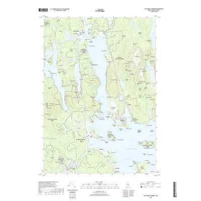
2018 Map of Southwest Harbor
USGS Topo · Published 2018About this map
Mount Desert Island is anchored by the deep indentation of Somes Sound, which nearly bisects the landmass. This 2018 survey documents a landscape where traditional maritime settlements like Southwest Harbor, Northeast Harbor, and Manset interface with the extensive protected lands of Acadia National Park. The industrial history of the island is preserved in names like Hall Quarry, while its early settlement patterns are visible through numerous small family cemeteries, including the Clark Family Burying Ground and Moore Family Burial Ground. Significant terrain features such as Mansell Mtn and Bernard Mtn loom over Long Pond, illustrating the dramatic relief of the Maine coast. Small islands and ledges, such as Sutton Island and Greening Island, dot the surrounding waters of the Western Way and Eastern Way, marking the intricate shoreline of Hancock County.
Find a feature on this map
220 named features on this map. Tap any name to fly to it.
Don’t see what you’re looking for? This feature index may not catch every label — zoom into the map to look around manually.
Map Details
Editions of this 2018 Southwest Harbor Map
This is the sole edition of this map. No revisions or reprints were ever made.
Other maps of this area

1904 · Mount Desert
USGS Topo · 1:62,500

1904 · Swan Island
USGS Topo · 1:62,500

1904 · Bar Harbor
USGS Topo · 1:62,500

1942 · Bar Harbor
USGS Topo · 1:62,500

1942 · Mount Desert
USGS Topo · 1:62,500

1943 · Swans Island
USGS Topo · 1:62,500

1945 · Swans Island
USGS Topo · 1:62,500

1948 · Bangor
USGS Topo · 1:250,000

1956 · Bar Harbor
USGS Topo · 1:62,500

1956 · Mount Desert
USGS Topo · 1:62,500