
1949 Map of Spartanburg
USGS Topo · Published 1949About this map
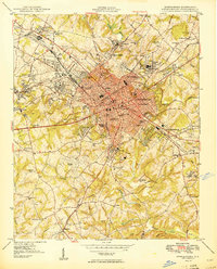
Spartanburg serves as the industrial and transit hub of this Piedmont landscape, shown shortly after the peak of its textile manufacturing era. A dense network of rail lines including the Southern and the Piedmont and Northern converge on the city, linking mill villages like Arkwright and Glendale to the wider region. Southeast of the city center, the sprawling footprint of Camp Croft occupies a significant portion of the terrain, reflecting the area's immediate post-war military significance.
Find a feature on this map
146 named features on this map. Tap any name to fly to it.
Don’t see what you’re looking for? This feature index may not catch every label — zoom into the map to look around manually.
Map Details
Editions of this 1949 Spartanburg Map
This is the sole edition of this map. No revisions or reprints were ever made.
Other maps of this area

1907 · Saluda
USGS Topo · 1:125,000

1909 · Gaffney
USGS Topo · 1:62,500

1935 · Greer
USGS Topo · 1:48,000

1938 · Greer
USGS Topo · 1:62,500

1941 · Spartanburg
USGS Topo · 1:250,000

1947 · Spartanburg
USGS Topo · 1:62,500
1949 · Spartanburg
USGS Topo · 1:24,000

1953 · Spartanburg
USGS Topo · 1:250,000

1953 · Charlotte
USGS Topo · 1:250,000

1954 · Charlotte
USGS Topo · 1:250,000