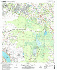
1995 Map of St. Gabriel
USGS Topo · Published 1998About this map
The Mississippi River forms the southwestern boundary of this landscape, where the fertile bottomlands of the Lower Mississippi Delta meet the developing southern reaches of Baton Rouge. This survey captures a region defined by its complex drainage network, including Bayou Manchac and Bayou Paul, which historically served as vital corridors through the low-lying terrain. The transition from the urban periphery of Kleinpeter to the agricultural and institutional lands further south is evident, particularly with the sprawling grounds of the Hunt Correctional Center and the Louisiana Correctional Institute For Women.
Find a feature on this map
65 named features on this map. Tap any name to fly to it.
Don’t see what you’re looking for? This feature index may not catch every label — zoom into the map to look around manually.
Map Details
Editions of this 1995 St. Gabriel Map
This is the sole edition of this map. No revisions or reprints were ever made.
Other maps of this area

1892 · Donaldsonville
USGS Topo · 1:62,500

1908 · Baton Rouge
USGS Topo · 1:62,500

1934 · Denham Springs
USGS Topo · 1:62,500

1935 · Gonzales
USGS Topo · 1:31,680

1936 · White Castle
USGS Topo · 1:62,500

1939 · Denham Springs
USGS Topo · 1:62,500

1939 · Baton Rouge
USGS Topo · 1:62,500

1939 · Donaldsonville
USGS Topo · 1:62,500

1953 · Baton Rouge West
USGS Topo · 1:24,000

1953 · Plaquemine
USGS Topo · 1:24,000