Loading...
Loading map...1958 Map of St. Marys
USGS Topo · Published 1972About this map
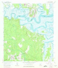
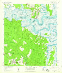
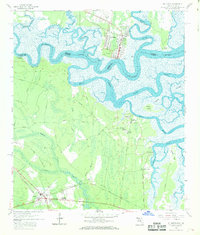
St Marys stands as the focal point of this coastal landscape, situated where the St Marys River carves a winding path between Georgia and Florida. The map details a complex hydraulic network of tidal flats and meandering channels, including the Bells River, Jolly River, and Tiger River. This 1970 photorevision documents the region's mid-century transit infrastructure, showing the St Marys RR serving the riverfront while the Seaboard Coast Line Railroad and the Buccaneer Trail anchor the southern settlement at Yulee.
Find a feature on this map
40 named features on this map. Tap any name to fly to it.
Don’t see what you’re looking for? This feature index may not catch every label — zoom into the map to look around manually.
Map Details
Date Portrayed1958
Date Published1972
PublisherU.S. Geological Survey
Map TypeTopographic
Scale1:24,000
Physical Dimensions23 x 26.9 inches
Editions of this 1958 St. Marys Map
Historical Maps of St. Marys Through Time
1 maps found
Featured Locations
Source Details
SourceU.S. Geological Survey
CopyrightPublic Domain