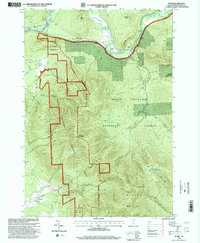
1995 Map of Stark
USGS Topo · Published 2000About this map
The Ammonoosuc River and its upper branches carve through the high terrain of Coos County, defining the valley corridors that support the settlements of Stark and Percy. In the mid-1990s, this landscape was dominated by the White Mountain National Forest, where the Pilot Range reaches its heights at Mount Cabot and The Horn. The map documents a blend of wilderness and local infrastructure, showing a Covered Bridge and several Cem sites near the river, while a Landing Strip and Bm Rr line trace the valley floor. Toward the south, the curious name of Lost Nation appears near Whipple Brook, where a Township Monument marks the border with Lancaster. These details illustrate the deep-rooted boundaries and small-scale developments within a largely protected forest system.
Find a feature on this map
45 named features on this map. Tap any name to fly to it.
Don’t see what you’re looking for? This feature index may not catch every label — zoom into the map to look around manually.
Map Details
Editions of this 1995 Stark Map
This is the sole edition of this map. No revisions or reprints were ever made.
Other maps of this area

1893 · Mt. Washington
USGS Topo · 1:62,500

1896 · Mt. Washington
USGS Topo · 1:62,500

1900 · Whitefield
USGS Topo · 1:62,500

1920 · Guildhall
USGS Topo · 1:62,500

1930 · Percy
USGS Topo · 1:62,500

1931 · Guildhall
USGS Topo · 1:48,000

1933 · Guildhall
USGS Topo · 1:48,000

1934 · Percy
USGS Topo · 1:62,500

1935 · Whitefield
USGS Topo · 1:48,000

1935 · Mt. Washington
USGS Topo · 1:62,500