2023 Map of Stottville
USGS Topo · Published 2023About this map
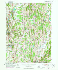
Kinderhook Creek winds through the northwest corner of this Columbia County landscape, marking the historic mill sites and industrial heritage of Stuyvesant Falls and Rossman. This 2023 survey documents a landscape defined by its small crossroads settlements and numerous community burial grounds, such as the Stuyvesant Falls Cem and Ghent Union Cem. The central and southern portions of the map reveal a rural character interspersed with aviation hubs like the Columbia County Airport and Klaverack Airport. In the southeast, the terrain shifts near Philmont and Mellenville, where Claverack Creek flows near the base of Mt Ida. The map provides a current record of local landmarks like Brick Tavern and Pulvers, offering genealogists and local historians an essential tool for locating family names and historic sites across this pocket of the Hudson Valley.
Find a feature on this map
131 named features on this map. Tap any name to fly to it.
Don’t see what you’re looking for? This feature index may not catch every label — zoom into the map to look around manually.
Map Details
Editions of this 2023 Stottville Map
This is the sole edition of this map. No revisions or reprints were ever made.