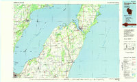
1984 Map of Sturgeon Bay
USGS Topo · Published 1985About this map
The Niagara Escarpment defines the geological character of the Door Peninsula in the mid-1980s, anchoring a landscape shaped by coastal industry and rural crossroads. The port at Sturgeon Bay serves as the primary hub, where the canal and harbor connect Green Bay to Lake Michigan. To the south, the agricultural grid is punctuated by small Belgian and German settlements such as Brussels, Luxemburg, and New Franken. Transport networks are well-defined, including the Green Bay and Western and Chicago and North Western rail lines that once moved goods through this timber and orchard region. Conservation areas like Potawatomi State Park and Whitefish Dunes State Park protect the shoreline, while numerous local quarries indicate the continued importance of the peninsula's bedrock to the local economy.
Find a feature on this map
103 named features on this map. Tap any name to fly to it.
Don’t see what you’re looking for? This feature index may not catch every label — zoom into the map to look around manually.
Map Details
Editions of this 1984 Sturgeon Bay Map
2 editions found
Other maps of this area

1939 · Marinette
USGS Topo · 1:48,000

1939 · Porterfield
USGS Topo · 1:48,000

1941 · Coleman
USGS Topo · 1:48,000

1942 · Coleman
USGS Topo · 1:48,000

1942 · Porterfield
USGS Topo · 1:48,000

1950 · Coleman
USGS Topo · 1:48,000

1952 · Casco
USGS Topo · 1:62,500

1954 · De Pere
USGS Topo · 1:62,500

1954 · Kewaunee
USGS Topo · 1:62,500

1954 · Green Bay West
USGS Topo · 1:24,000