1960 Map of Sturgeon Bay
USGS Topo · Published 1962About this map
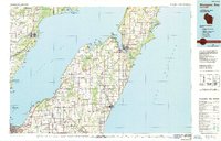
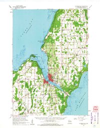
The city of Sturgeon Bay serves as the hub of this 1960 survey, bisected by its namesake waterway which connects Green Bay to Lake Michigan. The era’s transportation network is anchored by the Ahnapee and Western railroad and the County Fairground, illustrating the town's role as a regional center for Door County. Along the rugged shoreline of the peninsula, Potawatomi State Park preserves the wooded elevations near Sawyer Harbor, while small coastal settlements like Idlewild and Little Harbor line the western coast.
Find a feature on this map
62 named features on this map. Tap any name to fly to it.
Don’t see what you’re looking for? This feature index may not catch every label — zoom into the map to look around manually.
Map Details
Editions of this 1960 Sturgeon Bay Map
This is the sole edition of this map. No revisions or reprints were ever made.