
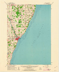
1960 Map of Algoma
USGS Topo · Published 1962About this map
The Ahnapee River winds its way toward the shores of Lake Michigan, anchoring the development of this coastal Wisconsin region. In the early 1960s, the port of Algoma serves as the primary hub, where the Ahnapee and Western railroad corridor meets the lake. This network of rails and waterways supported a landscape of small agricultural communities and local industry, evident in the numerous Gravel Pits and rural schools like East Maplewood Sch and Lakeview Sch.
Find a feature on this map
54 named features on this map. Tap any name to fly to it.
Don’t see what you’re looking for? This feature index may not catch every label — zoom into the map to look around manually.
Map Details
Editions of this 1960 Algoma Map
2 editions found
Other maps of this area

1952 · Casco
USGS Topo · 1:62,500

1954 · Kewaunee
USGS Topo · 1:62,500

1954 · Manitowoc
USGS Topo · 1:250,000

1958 · Manitowoc
USGS Topo · 1:250,000

1960 · Sturgeon Bay
USGS Topo · 1:62,500

1960 · Jacksonport
USGS Topo · 1:62,500

1961 · Little Sturgeon
USGS Topo · 1:62,500

1978 · Casco
USGS Topo · 1:24,000

1978 · Brussels
USGS Topo · 1:24,000
1978 · Kewaunee
USGS Topo · 1:24,000