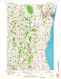
1978 Map of Kewaunee
USGS Topo · Published 1979About this map
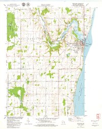
Kewaunee River meanders toward its mouth at Lake Michigan, anchoring the development of this lakeside community in the late 1970s. The map captures the interface between the urban grid of Kewaunee and the surrounding agricultural townships of West Kewaunee, Pierce, and Carlton. The industrial and maritime legacy of the area is evident in the Green Bay and Western railroad corridor and the Light Lighthouse standing at the harbor entrance. Inland, the landscape is defined by small crossroads like Krok and Birchwood, alongside significant conservation areas including the Kewaunee River State Public Fishery Area. Local genealogy is well-served by the inclusion of several rural burial sites, such as Volunteer Cem, St Peters Ch Cem, and Forest View Cem, providing a clear record of the area's rural settlement pattern during this era.
Find a feature on this map
47 named features on this map. Tap any name to fly to it.
Don’t see what you’re looking for? This feature index may not catch every label — zoom into the map to look around manually.
Map Details
Editions of this 1978 Kewaunee Map
This is the sole edition of this map. No revisions or reprints were ever made.
Historical Maps of Kewaunee Through Time
7 maps found