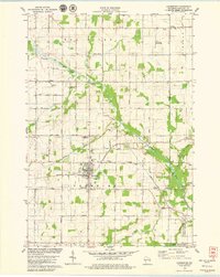
1978 Map of Luxemburg
USGS Topo · Published 1979About this map
Luxemburg serves as the central hub for this late-1970s landscape in Kewaunee County, where the agricultural grid is defined by the Green Bay and Western railroad corridor. The area is dotted with small, historic hamlets such as Thiry Daems, Lincoln, and Tonet, each reflecting the rural settlement patterns of the Kewaunee River basin. Significant for local historians, the map identifies several parish and community landmarks including Lincoln Chapel, St Martins Cem, and the uniquely named Spiritualist Cem. The winding course of the Kewaunee River and its tributaries like School Creek and Scarboro Creek dictate the local topography, while the Little Scarboro State Public Fishery Area in the south highlights the region's managed natural resources. Aviation and recreation also appear through the Funk Farms Landing Strip and the North Brook Country Club, alongside the industrial presence of numerous Gravel Pits.
Find a feature on this map
46 named features on this map. Tap any name to fly to it.
Don’t see what you’re looking for? This feature index may not catch every label — zoom into the map to look around manually.
Map Details
Editions of this 1978 Luxemburg Map
This is the sole edition of this map. No revisions or reprints were ever made.
Other maps of this area

1952 · Casco
USGS Topo · 1:62,500

1954 · Kewaunee
USGS Topo · 1:62,500

1954 · Denmark
USGS Topo · 1:62,500

1954 · New Franken
USGS Topo · 1:62,500

1954 · Manitowoc
USGS Topo · 1:250,000

1958 · Manitowoc
USGS Topo · 1:250,000

1978 · Casco
USGS Topo · 1:24,000

1978 · Namur
USGS Topo · 1:24,000

1978 · Poland
USGS Topo · 1:24,000

1978 · Stangelville
USGS Topo · 1:24,000