
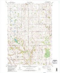
1978 Map of Poland
USGS Topo · Published 1979About this map
Poland serves as a central point in this late-1970s landscape of eastern Wisconsin, where the town lines of Humboldt, Eaton, Montpellier, and Denmark converge. The area is defined by a grid of rural roads such as Townline Road and Pine Grove Road, which connect small communities like Henrysville, Scarboro, and Langes Corners. The Chicago and North Western railroad cuts diagonally through the southern portion of the quadrangle, passing near gravel pits and local landmarks.
Find a feature on this map
47 named features on this map. Tap any name to fly to it.
Don’t see what you’re looking for? This feature index may not catch every label — zoom into the map to look around manually.
Map Details
Editions of this 1978 Poland Map
2 editions found
Other maps of this area

1952 · Casco
USGS Topo · 1:62,500

1954 · Kewaunee
USGS Topo · 1:62,500

1954 · Denmark
USGS Topo · 1:62,500

1954 · New Franken
USGS Topo · 1:62,500

1954 · Green Bay East
USGS Topo · 1:24,000

1954 · Manitowoc
USGS Topo · 1:250,000

1954 · Bellevue
USGS Topo · 1:24,000

1958 · Manitowoc
USGS Topo · 1:250,000

1978 · Denmark
USGS Topo · 1:24,000

1978 · Stangelville
USGS Topo · 1:24,000