
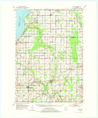
1952 Map of Casco
USGS Topo · Published 1954About this map
Dairy farming and rural commerce define this mid-century landscape along the border of Door and Kewaunee Counties. The Casco and Western railroad forms a vital transport corridor through the heart of the region, connecting Casco Junction and Luxemburg to the wider world. This network supported a dense distribution of one-room schoolhouses and parish churches that served as the social anchors for scattered agricultural hamlets like Slovan, Rio Creek, and Rosiere.
Find a feature on this map
68 named features on this map. Tap any name to fly to it.
Don’t see what you’re looking for? This feature index may not catch every label — zoom into the map to look around manually.
Map Details
Editions of this 1952 Casco Map
2 editions found
Other maps of this area

1954 · Kewaunee
USGS Topo · 1:62,500

1954 · Denmark
USGS Topo · 1:62,500

1954 · New Franken
USGS Topo · 1:62,500

1954 · Manitowoc
USGS Topo · 1:250,000

1956 · Oconto
USGS Topo · 1:62,500

1958 · Manitowoc
USGS Topo · 1:250,000

1960 · Sturgeon Bay
USGS Topo · 1:62,500

1960 · Algoma
USGS Topo · 1:62,500

1961 · Little Sturgeon
USGS Topo · 1:62,500
1974 · Oconto SE
USGS Topo · 1:24,000