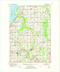
1952 Map of Casco
USGS Topo · Published 1975About this map
The agricultural heartland of the Door Peninsula and Kewaunee County is defined here by a dense grid of rural schools and Catholic parishes established by Belgian and European settlers. The Kewaunee Green Bay and Western railroad serves as the primary industrial artery, connecting Casco Junction with established village centers like Luxemburg and Casco. Evidence of the region’s glacial geology is visible in the numerous Gravel Pits and the Rocky Glen terrain.
Find a feature on this map
73 named features on this map. Tap any name to fly to it.
Don’t see what you’re looking for? This feature index may not catch every label — zoom into the map to look around manually.
Map Details
Editions of this 1952 Casco Map
2 editions found
Other maps of this area

1952 · Casco
USGS Topo · 1:62,500

1954 · Kewaunee
USGS Topo · 1:62,500

1954 · Denmark
USGS Topo · 1:62,500

1954 · New Franken
USGS Topo · 1:62,500

1954 · Manitowoc
USGS Topo · 1:250,000

1956 · Oconto
USGS Topo · 1:62,500

1958 · Manitowoc
USGS Topo · 1:250,000

1960 · Sturgeon Bay
USGS Topo · 1:62,500

1960 · Algoma
USGS Topo · 1:62,500

1961 · Little Sturgeon
USGS Topo · 1:62,500