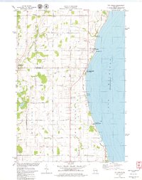
1978 Map of Two Creeks
USGS Topo · Published 1979About this map
Lake Michigan's western shoreline dominates this late-1970s landscape, where energy infrastructure and glacial history meet the rural coast. The map highlights the significant presence of both the Kewaunee Nuclear Powerplant and the Point Beach Nuclear Powerplant along the lakefront, marking a transition toward modern industrial utility. Inland, the terrain remains deeply tied to its small-town roots, centered on communities like Tisch Mills, Norman, and Two Creeks. The unique Two Creeks Buried State Forest and nearby Two Creeks County Park preserve the lake's ecological and geological heritage, while family-named roads such as Zander Road and Assman Road crisscross the agricultural plots. The East Twin River carves through the western section near Tisch Mills, providing a glimpse into the drainage patterns of this coastal agricultural region before it reaches the great lake.
Find a feature on this map
42 named features on this map. Tap any name to fly to it.
Don’t see what you’re looking for? This feature index may not catch every label — zoom into the map to look around manually.
Map Details
Editions of this 1978 Two Creeks Map
2 editions found
Other maps of this area

1954 · Kewaunee
USGS Topo · 1:62,500

1954 · Manitowoc
USGS Topo · 1:62,500

1954 · Manitowoc
USGS Topo · 1:250,000

1958 · Manitowoc
USGS Topo · 1:250,000
1978 · Two Rivers
USGS Topo · 1:24,000

1978 · Stangelville
USGS Topo · 1:24,000

1978 · Larrabee
USGS Topo · 1:24,000

1978 · Kewaunee
USGS Topo · 1:24,000

1978 · Mishicot
USGS Topo · 1:24,000

1984 · Manitowoc
USGS Topo · 1:100,000