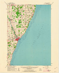
1960 Map of Algoma
USGS Topo · Published 1962About this map
Algoma serves as the focal point of this 1960s coastal study, situated where the Ahnapee and Western Creek meets Lake Michigan. The town’s harbor is clearly marked with Water Lights and a nearby Hospital, while the industrial and transport infrastructure is defined by the Ahnapee and Western railroad corridor. The surrounding landscape in Kewaunee and Door Counties is a mix of agricultural land and wooded patches, dotted with essential community hubs like the Maplewood Sch and the St Paul's Sch.
Find a feature on this map
45 named features on this map. Tap any name to fly to it.
Don’t see what you’re looking for? This feature index may not catch every label — zoom into the map to look around manually.
Map Details
Editions of this 1960 Algoma Map
2 editions found
Other maps of this area

1952 · Casco
USGS Topo · 1:62,500

1954 · Kewaunee
USGS Topo · 1:62,500

1954 · Manitowoc
USGS Topo · 1:250,000

1958 · Manitowoc
USGS Topo · 1:250,000

1960 · Sturgeon Bay
USGS Topo · 1:62,500

1960 · Jacksonport
USGS Topo · 1:62,500

1960 · Algoma
USGS Topo · 1:62,500

1961 · Little Sturgeon
USGS Topo · 1:62,500

1978 · Casco
USGS Topo · 1:24,000

1978 · Brussels
USGS Topo · 1:24,000