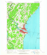
1939 Map of Marinette
USGS Topo · Published 1939About this map
Marinette and the neighboring settlement of Peshtigo anchor this 1939 survey of the Wisconsin-Michigan border. The industrial and maritime character of the region is evident in the dense street grids and the numerous schoolhouses dotting the rural townships, including McKinley Sch, Washington Sch, and Grant Sch. The border between the two states follows the winding path of the Menominee River past Chappie Rapids to its mouth at Green Bay, where the Menominee LH lighthouse and the natural projection of Sea Gull Bar mark the harbor entrance.
Find a feature on this map
39 named features on this map. Tap any name to fly to it.
Don’t see what you’re looking for? This feature index may not catch every label — zoom into the map to look around manually.
Map Details
Editions of this 1939 Marinette Map
This is the sole edition of this map. No revisions or reprints were ever made.
Historical Maps of Marinette Through Time
3 maps found