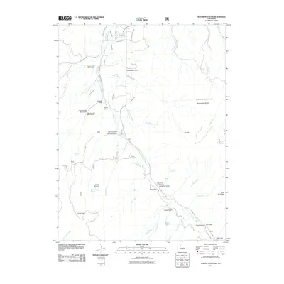
2011 Map of Suicide Mountain
USGS Topo · Published 2011About this map
Gypsum Creek carves a central path through this landscape, flanked by a complex system of agricultural water management features like the McBrayer and Fenner Ditch and the Ho O R Ditch. The presence of Quaker Corral and the Gypsum Creek Ranch Airport suggests a history of ranching and high-altitude land use. To the east, the terrain rises toward North Hardscrabble Mountain and Hardscrabble Saddle, while the western portion is dominated by the namesake Suicide Mountain and the deep drainage of Fish Pond Canyon. Notable landmarks for local researchers include several named springs and small bodies of water such as Borah Lake and The Beaver Ponds. The road network is largely defined by utility corridors and service routes, including Powerline - Gypsum and Cottonwood Pass Rd.
Find a feature on this map
61 named features on this map. Tap any name to fly to it.
Don’t see what you’re looking for? This feature index may not catch every label — zoom into the map to look around manually.
Map Details
Editions of this 2011 Suicide Mountain Map
This is the sole edition of this map. No revisions or reprints were ever made.
Other maps of this area

1909 · Mount Jackson
USGS Topo · 1:125,000

1911 · Mount Jackson
USGS Topo · 1:125,000

1927 · Glenwood Springs
USGS Topo · 1:125,000

1930 · Glenwood Springs
USGS Topo · 1:125,000

1957 · Leadville
USGS Topo · 1:250,000

1959 · Leadville
USGS Topo · 1:250,000

1960 · Leadville
USGS Topo · 1:250,000

1961 · Leon
USGS Topo · 1:24,000

1961 · Cottonwood Pass
USGS Topo · 1:24,000
1961 · Toner Reservoir
USGS Topo · 1:24,000