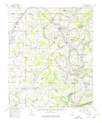
1962 Map of Sumner
USGS Topo · Published 1980About this map
The alluvial landscape of the Mississippi Delta is meticulously detailed here, centered on the Sumner and Webb communities along the Illinois Central corridor. The map highlights a complex hydrography of bayous and brakes, including the winding Cassidy Bayou and the Quiver River, which defined the region's agricultural boundaries. Notable for its high density of rural religious and social centers, the sheet identifies dozens of country churches such as New Bethel Ch, Hicks Chapel, and Friendship West Ch, alongside the Black Bayou Sch.
Find a feature on this map
95 named features on this map. Tap any name to fly to it.
Don’t see what you’re looking for? This feature index may not catch every label — zoom into the map to look around manually.
Map Details
Editions of this 1962 Sumner Map
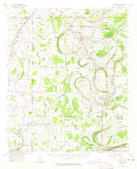
2 editions found
Other maps of this area

1931 · Schlater
USGS Topo · 1:48,000

1931 · Sumner
USGS Topo · 1:48,000

1931 · Drew
USGS Topo · 1:48,000

1932 · Philipp
USGS Topo · 1:48,000

1932 · Tutwiler
USGS Topo · 1:48,000

1934 · Cleveland
USGS Topo · 1:62,500

1934 · Schlater
USGS Topo · 1:62,500

1935 · Clarksdale
USGS Topo · 1:62,500

1935 · Crowder
USGS Topo · 1:62,500

1935 · Sumner
USGS Topo · 1:62,500