
1931 Map of Tejon Hills
USGS Topo · Published 1931About this map
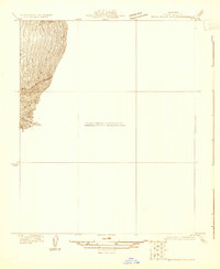
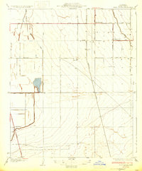
The Tejon Hills rise sharply from the valley floor in this 1931 survey, which captures a critical point of land division in Kern County. The map clearly illustrates the meeting of two primary geographic survey systems at the Mt Diablo Base and Meridian and San Bernardino Base and Meridian boundary. This convergence of surveying baselines highlights the transition between central and southern California land management during the early 20th century.
Find a feature on this map
8 named features on this map. Tap any name to fly to it.
Don’t see what you’re looking for? This feature index may not catch every label — zoom into the map to look around manually.
Map Details
Editions of this 1931 Tejon Hills Map
This is the sole edition of this map. No revisions or reprints were ever made.
Other maps of this area

1903 · Tejon
USGS Topo · 1:125,000

1914 · Caliente
USGS Topo · 1:125,000

1930 · Weed Patch
USGS Topo · 1:31,680
1930 · Bear Mountain
USGS Topo · 1:31,680
1930 · Arvin
USGS Topo · 1:31,680
1931 · West of Tejon Hills
USGS Topo · 1:31,680
1933 · Arvin
USGS Topo · 1:31,680
1933 · Weed Patch
USGS Topo · 1:31,680
1933 · Tejon Hills
USGS Topo · 1:31,680
1933 · Bear Mountain
USGS Topo · 1:31,680