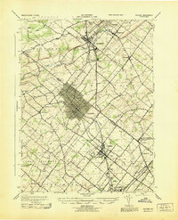
1943 Map of Telford
USGS Topo · Published 1943About this map
The Reading railroad corridor serves as the primary spine of development through this 1943 survey of Bucks and Montgomery Counties, linking the industrial and residential hubs of Souderton, Telford, and Sellersville. The landscape transitions from the more densely settled borough of Lansdale in the south to the creek-carved terrain of West Rockhill and the Ridge Valley in the north. This wartime mapping project, produced by the Corps of Engineers, records a complex network of township roads connecting smaller crossroads settlements like Franconia, Line Lexington, and Mainland. The presence of several distinct watercourses, including Northeast Branch Perkiomen Creek and Nashaminy Creek, illustrates how local topography influenced early settlement patterns and the placement of community landmarks like St Peters Ch and Menlo Park.
Find a feature on this map
47 named features on this map. Tap any name to fly to it.
Don’t see what you’re looking for? This feature index may not catch every label — zoom into the map to look around manually.
Map Details
Editions of this 1943 Telford Map
This is the sole edition of this map. No revisions or reprints were ever made.
Other maps of this area

1888 · Quakertown
USGS Topo · 1:62,500

1890 · Doylestown
USGS Topo · 1:62,500

1890 · Quakertown
USGS Topo · 1:62,500

1891 · Doylestown
USGS Topo · 1:62,500

1893 · Germantown
USGS Topo · 1:62,500

1894 · Quakertown
USGS Topo · 1:62,500

1894 · Norristown
USGS Topo · 1:62,500

1894 · Germantown
USGS Topo · 1:62,500

1895 · Norristown
USGS Topo · 1:62,500

1896 · Germantown
USGS Topo · 1:62,500