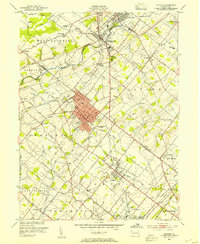
1953 Map of Telford
USGS Topo · Published 1954About this map
The Reading railroad corridor anchors this mid-century portrait of the North Penn region, where industrial hubs like Souderton and Telford contrast with the surrounding agricultural landscapes of Franconia and Hilltown. This era shows a dense network of local schools and churches, including the Jerusalem Union Ch and Gehmans Sch, which served established farming communities before the rapid post-war suburban expansion fully transformed the Bucks and Montgomery county line.
Find a feature on this map
80 named features on this map. Tap any name to fly to it.
Don’t see what you’re looking for? This feature index may not catch every label — zoom into the map to look around manually.
Map Details
Editions of this 1953 Telford Map
This is the sole edition of this map. No revisions or reprints were ever made.
Other maps of this area

1888 · Quakertown
USGS Topo · 1:62,500

1890 · Doylestown
USGS Topo · 1:62,500

1890 · Quakertown
USGS Topo · 1:62,500

1891 · Doylestown
USGS Topo · 1:62,500

1893 · Germantown
USGS Topo · 1:62,500

1894 · Quakertown
USGS Topo · 1:62,500

1894 · Norristown
USGS Topo · 1:62,500

1894 · Germantown
USGS Topo · 1:62,500

1895 · Norristown
USGS Topo · 1:62,500

1896 · Germantown
USGS Topo · 1:62,500