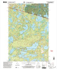
1999 Map of Tenderfoot Lake
USGS Topo · Published 2004About this map
Ottawa National Forest and the Northern Highland American Legion State Forest meet at the Michigan-Wisconsin border in this detailed study of Northwoods lake country. The landscape is defined by an intricate network of water bodies, including Little Presque Isle Lake, Fishtrap Lake, and Morton Lake, separated by a maze of logging and forest roads. Named routes such as Timber Wolf Road, Blue Heron Road, and Bear Trail provide access to the deep woods of Land O' Lakes and Boulder Junction.
Find a feature on this map
71 named features on this map. Tap any name to fly to it.
Don’t see what you’re looking for? This feature index may not catch every label — zoom into the map to look around manually.
Map Details
Editions of this 1999 Tenderfoot Lake Map
This is the sole edition of this map. No revisions or reprints were ever made.
Other maps of this area

1939 · Trout Lake
USGS Topo · 1:48,000

1946 · Star Lake
USGS Topo · 1:48,000

1946 · Trout Lake
USGS Topo · 1:48,000

1949 · Trout Lake
USGS Topo · 1:48,000

1950 · Star Lake
USGS Topo · 1:48,000

1952 · Thayer
USGS Topo · 1:62,500

1955 · Marenisco
USGS Topo · 1:62,500

1955 · Starlake
USGS Topo · 1:62,500

1955 · Boulder Junction
USGS Topo · 1:62,500

1958 · Iron River
USGS Topo · 1:250,000