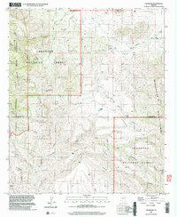
1996 Map of The Mesas
USGS Topo · Published 2003About this map
The Mesas and the high desert divides of the Winchester Mountains dominate this 1996 survey of the southeastern Arizona borderlands. The landscape is defined by its hydrological network, where seasonal drainages like Ash Creek and Brush Creek cut through the steep topography of the Coronado National Forest. This era of the late twentieth century shows a region primarily managed for conservation and wilderness, with the Galiuro Wilderness and Redfield Canyon Wilderness preserving the primitive character of the terrain. Human presence is sparse but historically significant, marked by a lone Cem and scattered mineral exploration at a Prospect. Long-standing water sources like Eagle Tanks, Whalen Tank, and Double R Spring indicate the essential infrastructure required for ranching and survival in this arid environment along the Graham and Cochise county line.
Find a feature on this map
37 named features on this map. Tap any name to fly to it.
Don’t see what you’re looking for? This feature index may not catch every label — zoom into the map to look around manually.
Map Details
Editions of this 1996 The Mesas Map
This is the sole edition of this map. No revisions or reprints were ever made.
Other maps of this area

1938 · Galiuro Mts
USGS Topo · 1:48,000

1940 · Sierra Bonita Ranch
USGS Topo · 1:62,500

1942 · Sierra Bonita Ranch
USGS Topo · 1:62,500

1943 · Galiuro Mts
USGS Topo · 1:62,500

1943 · Sierra Bonita Ranch
USGS Topo · 1:62,500

1943 · Winchester Mts.
USGS Topo · 1:62,500

1945 · Redington
USGS Topo · 1:62,500

1945 · Winchester Mts.
USGS Topo · 1:62,500

1956 · Tucson
USGS Topo · 1:250,000

1957 · Redington
USGS Topo · 1:62,500