
1939 Map of Thebes
USGS Topo · Published 1946About this map
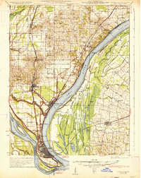
The Mississippi River creates a dynamic western boundary for Alexander County in this pre-war survey, where the river's winding course is marked by shifting landforms like Burnham Island and Bumgard Island. The settlement of Thebes serves as a central hub, flanked by rail infrastructure from the Missouri Pacific RR and the Chicago and Eastern Illinois RR. This era reveals a landscape deeply connected to the river's whims, evidenced by the numerous chutes and towheads such as Anita Towhead and Santa Fe Chute.
Find a feature on this map
85 named features on this map. Tap any name to fly to it.
Don’t see what you’re looking for? This feature index may not catch every label — zoom into the map to look around manually.
Map Details
Editions of this 1939 Thebes Map
This is the sole edition of this map. No revisions or reprints were ever made.
Other maps of this area

1920 · Jonesboro
USGS Topo · 1:62,500

1920 · Dongola
USGS Topo · 1:62,500

1922 · Cape Girardeau
USGS Topo · 1:62,500

1923 · Dongola
USGS Topo · 1:62,500

1923 · Jonesboro
USGS Topo · 1:62,500

1924 · Cape Girardeau
USGS Topo · 1:62,500

1931 · Sikeston
USGS Topo · 1:62,500

1931 · Cairo
USGS Topo · 1:62,500
1933 · Cairo
USGS Topo · 1:62,500

1934 · Thebes
USGS Topo · 1:62,500