2023 Map of Thiells
USGS Topo · Published 2023About this map
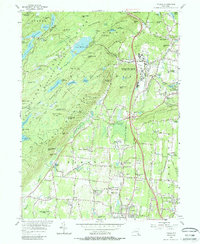
The Ramapo Mountains dominate the western landscape of this Rockland County corridor, where the rugged topography of Hogencamp Mountain and Jackie Jones Mountain transitions into the dense suburban developments of Spring Valley and New City. This modern survey illustrates the proximity of wild lands to significant residential growth, anchored by the vast recreational area around Lake Welch and the forested slopes of Mine Ridge. The terrain is marked by a complex hydrological network including Minisceongo Creek and the Mahwah River, which historically dictated the placement of early industry at sites like File Factory Hollow.
Find a feature on this map
118 named features on this map. Tap any name to fly to it.
Don’t see what you’re looking for? This feature index may not catch every label — zoom into the map to look around manually.
Map Details
Editions of this 2023 Thiells Map
This is the sole edition of this map. No revisions or reprints were ever made.