
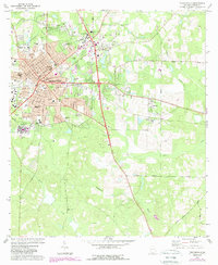
2024 Map of Thomasville
USGS Topo · Published 2024About this map
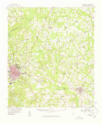
The Thomas County Courthouse stands at the center of this map, serving as the civic anchor for a landscape where urban development meets large plantation tracts. In Thomasville, a dense network of streets and historic institutions like Thomas University and the Southwest Georgia Technical College reflect the area's growth as a regional hub. The geography is marked by numerous family and community burial grounds, from the large Magnolia Cem and Laurel Hill Cem near the city center to smaller, more isolated sites like Beverly Cem and Vann Cem further south.
Find a feature on this map
216 named features on this map. Tap any name to fly to it.
Don’t see what you’re looking for? This feature index may not catch every label — zoom into the map to look around manually.
Map Details
Editions of this 2024 Thomasville Map
This is the sole edition of this map. No revisions or reprints were ever made.
Historical Maps of Thomasville Through Time
3 maps found
Featured Locations
- Newark, GA
- Thomasville, GA
- Theodore Heights, Thomasville
- Fletcherville, Thomasville
- McLoughlin Heights, Thomasville