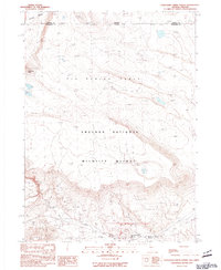
1990 Map of Thousand Creek Spring
USGS Topo · Published 1990About this map
Sheldon National Wildlife Refuge dominates this high desert landscape along the Nevada-Oregon border, where the Great Basin terrain is marked by distinctive plateaus and seasonal water sources. The map captures the remote character of the region as it appeared in the late 1980s, centered on the expansive Big Spring Table. Human presence is sparse, represented by McKenney Camp and several identified prospects and a quarry, indicating small-scale exploration in this protected habitat.
Find a feature on this map
18 named features on this map. Tap any name to fly to it.
Don’t see what you’re looking for? This feature index may not catch every label — zoom into the map to look around manually.
Map Details
Editions of this 1990 Thousand Creek Spring Map
This is the sole edition of this map. No revisions or reprints were ever made.
Other maps of this area

1886 · Disaster
USGS Topo · 1:250,000

1889 · Long Valley
USGS Topo · 1:250,000

1893 · Disaster
USGS Topo · 1:250,000

1954 · Vya
USGS Topo · 1:250,000

1955 · Adel
USGS Topo · 1:250,000

1957 · Adel
USGS Topo · 1:250,000

1958 · Vya
USGS Topo · 1:250,000

1958 · Adel
USGS Topo · 1:250,000

1962 · Vya
USGS Topo · 1:250,000

1962 · Adel
USGS Topo · 1:250,000