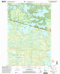
1999 Map of Thousand Island Lake
USGS Topo · Published 2005About this map
Ottawa National Forest and the Northern Highland American Legion State Forest meet at the boundary of Michigan and Wisconsin, forming a vast complex of glacial water bodies and protected woodlands. This late-twentieth-century topography shows the transition between the Bessemer and Watersmeet Ranger Districts, where the Sylvania Wilderness preserves a primitive character. The landscape is defined by an intricate network of lakes, including the expansive Thousand Island Lake, Cisco Lake, and Lindsley Lake. These waters are connected by a system of land features such as Indian Point and Meadowwoods Point, while cultural footprints are visible in the form of secluded Boat Ramps and a Footbridge near Mamie Lake. The map details the remote character of this borderland, where Helen Creek Road provides rare access into the densely wooded terrain surrounding Fishhawk Lake and Poor Lake.
Find a feature on this map
70 named features on this map. Tap any name to fly to it.
Don’t see what you’re looking for? This feature index may not catch every label — zoom into the map to look around manually.
Map Details
Editions of this 1999 Thousand Island Lake Map
This is the sole edition of this map. No revisions or reprints were ever made.
Other maps of this area

1939 · Trout Lake
USGS Topo · 1:48,000

1946 · Star Lake
USGS Topo · 1:48,000

1946 · Trout Lake
USGS Topo · 1:48,000

1949 · Trout Lake
USGS Topo · 1:48,000

1950 · Star Lake
USGS Topo · 1:48,000

1952 · Thayer
USGS Topo · 1:62,500

1955 · Marenisco
USGS Topo · 1:62,500

1955 · Starlake
USGS Topo · 1:62,500

1955 · Boulder Junction
USGS Topo · 1:62,500

1958 · Iron River
USGS Topo · 1:250,000