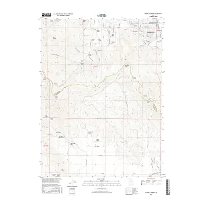
2017 Map of Tickville Spring
USGS Topo · Published 2017About this map
Riverton and Herriman occupy the northeastern corner of this landscape, marking the edge of suburban growth against the slopes of the Traverse Mountains and the southern Oquirrh Mountains. The terrain transitions sharply from the residential developments of Herriman to the high ridges of Latimer Point and Black Ridge. The boundary between Salt Lake County and Utah County bisects the map, separating these northern settlements from the broad expanse of Cedar Valley to the south. Historically significant water sources and drainage patterns define the interior, including Tickville Spring, Rose Canyon Spring, and Oak Springs. The map documents a network of canyons and gulches like Butterfield Canyon and Tickville Gulch that have long provided access through the mountains. This 2017 data reflects the modern road infrastructure, including the Mountain View Corridor, as it integrates with older mountain routes like Yellow Fork Canyon Rd.
Find a feature on this map
74 named features on this map. Tap any name to fly to it.
Don’t see what you’re looking for? This feature index may not catch every label — zoom into the map to look around manually.
Map Details
Editions of this 2017 Tickville Spring Map
This is the sole edition of this map. No revisions or reprints were ever made.
Other maps of this area

1885 · Salt Lake
USGS Topo · 1:250,000

1885 · Tooele Valley
USGS Topo · 1:250,000

1915 · Fairfield
USGS Topo · 1:62,500

1917 · Fairfield
USGS Topo · 1:62,500

1925 · Ft. Douglas
USGS Topo · 1:125,000

1928 · Ft. Douglas
USGS Topo · 1:125,000

1951 · Jordan Narrows
USGS Topo · 1:24,000
1951 · Saratoga Springs
USGS Topo · 1:24,000

1951 · Midvale
USGS Topo · 1:24,000

1952 · Bingham Canyon
USGS Topo · 1:24,000