
1941 Map of Timber
USGS Topo · Published 1941About this map
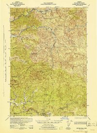
Timber and the surrounding upper Nehalem River basin are shown here during a period of intensive industrial logging and recovery from significant forest fires. The landscape is marked by the scars of the Burned 1933 and Burned 1939 events, yet it remains a hub of activity for the Southern Pacific railroad and numerous timber operations. The map documents a network of worker camps, including the Standard Logging Co Camp, Gonnacher Logging Camp, and the Stimson Lumber Co Logging Camp, alongside New Deal-era infrastructure like the Reeher CCC Camp and Scoggin Creek CCC Camp.
Find a feature on this map
55 named features on this map. Tap any name to fly to it.
Don’t see what you’re looking for? This feature index may not catch every label — zoom into the map to look around manually.
Map Details
Editions of this 1941 Timber Map
This is the sole edition of this map. No revisions or reprints were ever made.
Other maps of this area

1937 · Enright
USGS Topo · 1:62,500

1939 · Saddle Mountain
USGS Topo · 1:62,500

1940 · Vernonia
USGS Topo · 1:62,500

1941 · Keasey
USGS Topo · 1:62,500

1941 · Enright
USGS Topo · 1:62,500

1941 · Gales Creek
USGS Topo · 1:62,500

1941 · Yamhill
USGS Topo · 1:62,500
1942 · Ginger Peak
USGS Topo · 1:62,500

1942 · Yamhill
USGS Topo · 1:62,500
1942 · Fairdale
USGS Topo · 1:62,500