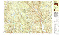
1987 Map of Tolland Center
USGS Topo · Published 1987About this map
Sandisfield State Forest and its neighbors, Algonquin State Forest and Tolland State Forest, dominate this landscape along the border of Massachusetts and Connecticut. The 1987 survey details a high-elevation environment of ridges and swamps, where the Farmington River flows south through the valley between Hanging Mountain and Babbitt Mountain. Small hamlets and named crossroads like Roosterville and McClaveville are scattered across the terrain, linked by routes such as West New Boston Sandisfield Road and Beech Plain Road. This era shows the region as a recreational and conservation corridor, characterized by numerous ponds like Windemere Lake and Thousand Acre Lake, alongside institutional landmarks including the YMCA Camp and Katherine School. Genealogists may find interest in the documented burial grounds, including Montville Cem and Roberts Cem, which anchor these small communities to their 18th and 19th-century origins.
Find a feature on this map
124 named features on this map. Tap any name to fly to it.
Don’t see what you’re looking for? This feature index may not catch every label — zoom into the map to look around manually.
Map Details
Editions of this 1987 Tolland Center Map
This is the sole edition of this map. No revisions or reprints were ever made.
Other maps of this area

1885 · Sheffield
USGS Topo · 1:62,500

1887 · Granville
USGS Topo · 1:62,500

1888 · Sheffield
USGS Topo · 1:62,500

1888 · Sandisfield
USGS Topo · 1:62,500

1889 · Granville
USGS Topo · 1:62,500

1891 · Sheffield
USGS Topo · 1:62,500

1892 · Winsted
USGS Topo · 1:62,500

1892 · Cornwall
USGS Topo · 1:62,500

1892 · Granby
USGS Topo · 1:62,500

1893 · Granville
USGS Topo · 1:62,500