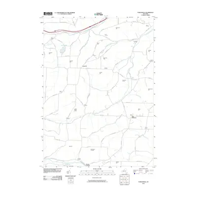
2010 Map of Towlesville
USGS Topo · Published 2010About this map
Towlesville serves as the central hub for this rural stretch of Steuben County, where the landscape is defined by its deep genealogical roots and varied terrain. The map is particularly notable for its high density of family-named landmarks and burial grounds, including the Hadleyville Cemetery, Durnian Cemetery, and Willis Cemetery, which offer valuable data for local researchers. Small agricultural enclaves like Knight Settlement and Buck Settlement are preserved here alongside larger topographic features such as Hathaways Pinnacle and Snell Hill. Waterways including Sinclair Creek and Chamberlain Brook wind through the hills toward the Canisteo River in the south, while modern aviation is represented by Dickinsons Airfield and Gaskins Hilltop Airport.
Find a feature on this map
88 named features on this map. Tap any name to fly to it.
Don’t see what you’re looking for? This feature index may not catch every label — zoom into the map to look around manually.
Map Details
Editions of this 2010 Towlesville Map
This is the sole edition of this map. No revisions or reprints were ever made.
Other maps of this area

1910 · Bath
USGS Topo · 1:62,500

1915 · Hornell
USGS Topo · 1:62,500

1918 · Hornell
USGS Topo · 1:62,500

1924 · Woodhull
USGS Topo · 1:48,000

1926 · Woodhull
USGS Topo · 1:62,500

1926 · Greenwood
USGS Topo · 1:62,500

1944 · Woodhull
USGS Topo · 1:62,500

1950 · Elmira
USGS Topo · 1:250,000

1953 · Cameron
USGS Topo · 1:24,000
1953 · Bath
USGS Topo · 1:24,000