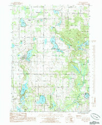
1985 Map of Trufant
USGS Topo · Published 1985About this map
Trufant and Gowen anchor this 1985 survey of a dense lake-and-river landscape along the border of Montcalm and Kent counties. The area is defined by its glacial hydrology, featuring dozens of named water bodies like Muskellunge Lake and the Flat River. Local heritage is preserved in landmarks such as the Cowden Lake Bible Ch, the Little Denmark Cem, and the Settlement Ch. These sites, along with several camps like Camp Anna Behrens, point to a history of rural community building and seasonal recreation. The road network, including Stanton Road and South Countyline Road, connects small clusters of residences to the natural resources that dominate the terrain. A notable amount of open water and marshland around Kendalville Lake and Maston Lake suggests a landscape that has remained largely resistant to heavy industrial development, preserving its mid-century recreational character.
Find a feature on this map
74 named features on this map. Tap any name to fly to it.
Don’t see what you’re looking for? This feature index may not catch every label — zoom into the map to look around manually.
Map Details
Editions of this 1985 Trufant Map
This is the sole edition of this map. No revisions or reprints were ever made.
Other maps of this area

1954 · Midland
USGS Topo · 1:250,000

1958 · Midland
USGS Topo · 1:250,000

1959 · Midland
USGS Topo · 1:250,000

1959 · Howard City
USGS Topo · 1:62,500

1964 · Six Lakes
USGS Topo · 1:24,000

1964 · Langston
USGS Topo · 1:24,000

1966 · Midland
USGS Topo · 1:250,000

1972 · Greenville West
USGS Topo · 1:24,000
1972 · Greenville East
USGS Topo · 1:24,000
1972 · Evans
USGS Topo · 1:24,000