
1982 Map of Tunk Lake
USGS Topo · Published 1983About this map
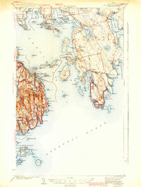
Tunk Lake dominates this 1980s landscape, serving as a central hub for the surrounding mountains and specialized wetlands of Hancock and Washington Counties. The Maine Central railroad cuts through the southern terrain, connecting isolated points like Goodwin Siding and the Tunk Lake station, while rugged elevations such as Catherine Mtn and Caribou Mountain overlook a complex network of smaller water bodies including Rainbow Pond and Wizard Pond.
Find a feature on this map
56 named features on this map. Tap any name to fly to it.
Don’t see what you’re looking for? This feature index may not catch every label — zoom into the map to look around manually.
Map Details
Editions of this 1982 Tunk Lake Map
This is the sole edition of this map. No revisions or reprints were ever made.
Other maps of this area

1902 · Cherryfield
USGS Topo · 1:62,500

1904 · Cherryfield
USGS Topo · 1:62,500

1904 · Bar Harbor
USGS Topo · 1:62,500

1904 · Petit Manan
USGS Topo · 1:62,500

1930 · Tunk Lake
USGS Topo · 1:48,000

1932 · Tunk Lake
USGS Topo · 1:62,500
1942 · Bar Harbor
USGS Topo · 1:62,500

1942 · Cherryfield
USGS Topo · 1:62,500

1942 · Tunk Lake
USGS Topo · 1:62,500

1948 · Bangor
USGS Topo · 1:250,000