1958 Map of Veblen
USGS Topo · Published 1959About this map
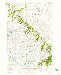
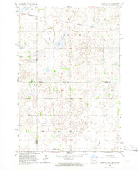
Veblen sits at the northeastern corner of this 1950s survey, marking a distinct transition between the lowlands and the higher reaches of the Coteau Des Prairies. The town serves as a focal point for the Minneapolis St Paul and Sault Ste Marie railroad, which skirts the northern edge of the terrain. South of the town, the landscape is defined by a dense concentration of glacial potholes and lakes, including Abraham Lake, Hill Lake, and Dumarce Lake.
Find a feature on this map
21 named features on this map. Tap any name to fly to it.
Don’t see what you’re looking for? This feature index may not catch every label — zoom into the map to look around manually.
Map Details
Editions of this 1958 Veblen Map
This is the sole edition of this map. No revisions or reprints were ever made.
Other maps of this area

1953 · Milbank
USGS Topo · 1:250,000

1958 · Milbank
USGS Topo · 1:250,000
1958 · Hillhead
USGS Topo · 1:24,000
1958 · Marlow
USGS Topo · 1:24,000
1958 · Veblen NE
USGS Topo · 1:24,000
1964 · Claire City NW
USGS Topo · 1:24,000
1964 · Claire City SW
USGS Topo · 1:24,000

1970 · Whitestone Lake
USGS Topo · 1:24,000
1970 · South Red Iron Lake
USGS Topo · 1:24,000
1970 · Lake City
USGS Topo · 1:24,000