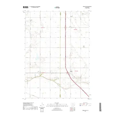
2017 Map of Vermillion SE
USGS Topo · Published 2017About this map
Junction City and the surrounding prairie of southeast South Dakota define this landscape along the Clay Co Union Co border. The map documents a highly structured grid of section lines and township roads, including Saginaw Rd and Fairview Ave, which connect several small, rural burial grounds essential for genealogical research. These include the Saint Peter Greenfield Cem in the northwest and Saint Mary Cem further east. Water features are relatively sparse, though the meandering course of Brule Cr and the drainage of Government Slough interrupt the geometric regularity of the farmland. Farther north, the small settlement of Midway sits at a crossroads, while the Ahlisborg Lutheran Cem serves as a landmark for the local community's historical roots in this agricultural region.
Find a feature on this map
36 named features on this map. Tap any name to fly to it.
Don’t see what you’re looking for? This feature index may not catch every label — zoom into the map to look around manually.
Map Details
Editions of this 2017 Vermillion SE Map
This is the sole edition of this map. No revisions or reprints were ever made.
Other maps of this area

1898 · Elk Point
USGS Topo · 1:125,000

1901 · Elk Point
USGS Topo · 1:125,000

1907 · Elk Point
USGS Topo · 1:125,000

1955 · Sioux City
USGS Topo · 1:250,000

1958 · Sioux City
USGS Topo · 1:250,000

1959 · Sioux City
USGS Topo · 1:250,000

1963 · Elk Point
USGS Topo · 1:24,000

1964 · Burbank
USGS Topo · 1:24,000

1964 · Maskell
USGS Topo · 1:24,000
1969 · Hub City
USGS Topo · 1:24,000