
1968 Map of Victor
USGS Topo · Published 1970About this map
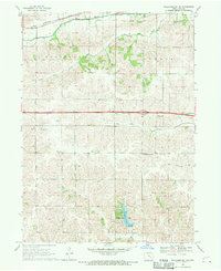
Victor serves as the primary hub along the Chicago Rock Island and Pacific railroad line, straddling the county line between Poweshiek Co and Iowa Co. This agricultural landscape is defined by the drainage systems of Big Bear Creek in the north and the North English River in the south, which dictate the placement of early townships like Warren and Lincoln. Local genealogy is well-documented through several burial grounds, including Calvary Cem, Wilson Cem, and the Longstreth Cem near the southern edge. The map also captures a period of transportation transition, showing both the modern 4 Lane highway and remnants of older infrastructure such as an Old Railroad Grade that once connected Guernsey to the surrounding farming communities. These corridors provide clear evidence of how rail and road developments shifted settlement patterns away from smaller junctions like Carnforth.
Find a feature on this map
23 named features on this map. Tap any name to fly to it.
Don’t see what you’re looking for? This feature index may not catch every label — zoom into the map to look around manually.
Map Details
Editions of this 1968 Victor Map
This is the sole edition of this map. No revisions or reprints were ever made.
Other maps of this area

1954 · Des Moines
USGS Topo · 1:250,000

1956 · Des Moines
USGS Topo · 1:250,000

1957 · Des Moines
USGS Topo · 1:250,000

1965 · Ladora
USGS Topo · 1:24,000

1968 · Deep River
USGS Topo · 1:24,000

1968 · Brooklyn
USGS Topo · 1:24,000

1968 · Belle Plaine SW
USGS Topo · 1:24,000
1968 · Williamsburg NW
USGS Topo · 1:24,000

1968 · Hartwick
USGS Topo · 1:24,000

1968 · Barnes City
USGS Topo · 1:24,000