1909 Map of Vidalia
USGS Topo · Published 1909About this map
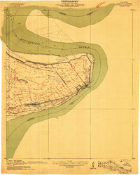
The Mississippi River creates a dramatic sweeping bend around Vidalia in this early twentieth-century survey of Concordia Parish. The landscape is defined by the levee system and the large agricultural estates that shaped the local economy, including Taconey Plantation, White Hall Plantation, and Scotland Plantation. The area shows a high density of rural religious life, with several named congregations such as Minorca Church, Mt Olive Church, and Starlight Church positioned near the riverbank or within the plantation grounds.
Find a feature on this map
14 named features on this map. Tap any name to fly to it.
Don’t see what you’re looking for? This feature index may not catch every label — zoom into the map to look around manually.
Map Details
Editions of this 1909 Vidalia Map
This is the sole edition of this map. No revisions or reprints were ever made.
Historical Maps of Natchez Through Time
1 maps found