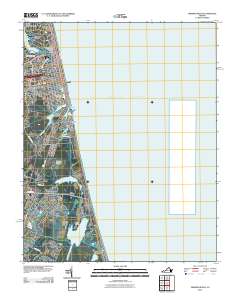
2010 Map of Virginia Beach
USGS Topo · Published 2010About this map
The Virginia Beach coastline in 2010 reveals a landscape defined by its lagoons, residential corridors, and military installations. The map traces the dense development between Little Neck Creek and the Atlantic Ocean, including the historic neighborhood of Seatack and the established communities of Linkhorn Park and Bird Neck Point. Significant water bodies like Lake Rudee and Lake Holly segment the northern urban grid, while the southern reaches transition into the more expansive wetland systems surrounding Lake Tecumseh and the residential stretch of Sandbridge Beach.
Find a feature on this map
36 named features on this map. Tap any name to fly to it.
Don’t see what you’re looking for? This feature index may not catch every label — zoom into the map to look around manually.
Map Details
Editions of this 2010 Virginia Beach Map
This is the sole edition of this map. No revisions or reprints were ever made.
Other maps of this area

1893 · Virginia Beach
USGS Topo · 1:125,000

1907 · Norfolk
USGS Topo · 1:125,000

1916 · Back Bay
USGS Topo · 1:62,500

1918 · Cape Henry
USGS Topo · 1:62,500

1919 · Cape Henry
USGS Topo · 1:62,500

1939 · Moyock
USGS Topo · 1:62,500

1943 · Back Bay
USGS Topo · 1:62,500

1946 · Moyock
USGS Topo · 1:62,500

1946 · Eastville
USGS Topo · 1:250,000

1946 · Currituck Sound
USGS Topo · 1:250,000