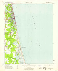
1955 Map of Virginia Beach
USGS Topo · Published 1958About this map
Virginia Beach presents a coastal landscape in transition during the mid-1950s, where traditional communities like Seatack and Atwoodtown sit alongside expanding military installations. The shoreline is defined by the Atlantic coast and a series of freshwater bodies including Lake Holly, Lake Rudee, and Lake Wesley. Local infrastructure and social life are anchored by landmarks such as Mt Olive Ch and Seatack Sch, while the Norfolk Southern line provides a rail connection to the burgeoning resort town.
Find a feature on this map
50 named features on this map. Tap any name to fly to it.
Don’t see what you’re looking for? This feature index may not catch every label — zoom into the map to look around manually.
Map Details
Editions of this 1955 Virginia Beach Map
This is the sole edition of this map. No revisions or reprints were ever made.
Other maps of this area

1893 · Virginia Beach
USGS Topo · 1:125,000

1907 · Norfolk
USGS Topo · 1:125,000

1916 · Back Bay
USGS Topo · 1:62,500

1918 · Cape Henry
USGS Topo · 1:62,500

1919 · Cape Henry
USGS Topo · 1:62,500

1939 · Moyock
USGS Topo · 1:62,500

1943 · Back Bay
USGS Topo · 1:62,500

1946 · Moyock
USGS Topo · 1:62,500

1946 · Eastville
USGS Topo · 1:250,000

1946 · Currituck Sound
USGS Topo · 1:250,000