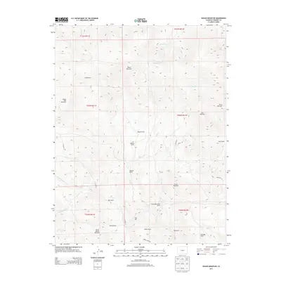
2013 Map of Waugh Mountain
USGS Topo · Published 2013About this map
Waugh Mountain and Loco Mountain dominate this central Colorado landscape, where steep high-country drainages converge in Fremont County. The terrain is defined by a series of significant peaks, including Stoney Face Mountain and Burris Mountain, cut by deep gulches such as Waugh Gulch and Galster Gulch. Water management and natural flow are traced through systems like W Waugh Cr, N Waugh Cr, and the notably named Quagmire Cr. A sparse network of local thoroughfares, including CO Road 12 and Broken Arrow Dr, provides the only modern access through these remote elevations. The map reveals a land primarily shaped by its hydrology and relief, from the heights of North Burno Mountain down to Antelope Gulch, reflecting the high-altitude wilderness character of the Southern Rockies.
Find a feature on this map
40 named features on this map. Tap any name to fly to it.
Don’t see what you’re looking for? This feature index may not catch every label — zoom into the map to look around manually.
Map Details
Editions of this 2013 Waugh Mountain Map
This is the sole edition of this map. No revisions or reprints were ever made.
Other maps of this area

1954 · Pueblo
USGS Topo · 1:250,000

1956 · Cameron Mountain
USGS Topo · 1:62,500

1957 · Pueblo
USGS Topo · 1:250,000

1958 · Pueblo
USGS Topo · 1:250,000

1959 · Black Mountain
USGS Topo · 1:62,500

1959 · Howard
USGS Topo · 1:62,500

1959 · Cotopaxi
USGS Topo · 1:62,500

1962 · Pueblo
USGS Topo · 1:250,000

1966 · Pueblo
USGS Topo · 1:250,000
1980 · Echo
USGS Topo · 1:24,000