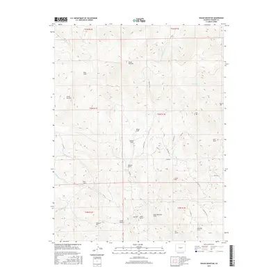
2016 Map of Waugh Mountain
USGS Topo · Published 2016About this map
Waugh Mountain dominates this Fremont County landscape, serving as a high-altitude anchor for a network of deeply etched drainages. The 2016 survey captures a high-country terrain defined by its gulches and named peaks, showing the transition from the steep slopes of Stoney Face Mtn and Loco Mtn down toward more accessible valley floors. The drainage pattern is complex, with headwaters like Gribbles Run and N Waugh Cr flowing from the central heights. Road access is largely provided by local routes such as Waugh Mtn Rd and Elkhorn Rd, which follow the natural contours of the land. This map is particularly valuable for identifying specific named landmarks like Red Hill and Galster Gulch that define property boundaries and historical land use in this part of the Colorado interior.
Find a feature on this map
46 named features on this map. Tap any name to fly to it.
Don’t see what you’re looking for? This feature index may not catch every label — zoom into the map to look around manually.
Map Details
Editions of this 2016 Waugh Mountain Map
This is the sole edition of this map. No revisions or reprints were ever made.
Other maps of this area

1954 · Pueblo
USGS Topo · 1:250,000

1956 · Cameron Mountain
USGS Topo · 1:62,500

1957 · Pueblo
USGS Topo · 1:250,000

1958 · Pueblo
USGS Topo · 1:250,000

1959 · Black Mountain
USGS Topo · 1:62,500

1959 · Howard
USGS Topo · 1:62,500

1959 · Cotopaxi
USGS Topo · 1:62,500

1962 · Pueblo
USGS Topo · 1:250,000

1966 · Pueblo
USGS Topo · 1:250,000
1980 · Echo
USGS Topo · 1:24,000