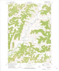
1973 Map of Waumandee
USGS Topo · Published 1975About this map
Waumandee and Montana are the primary hubs of this Buffalo County landscape, where agriculture and topography dictate the pattern of settlement. The terrain is defined by a dense network of coulees and valleys, such as Garden Valley, Jahns Valley, and Danuser Valley, which are separated by prominent high grounds like Montana Ridge and Glencoe Ridge. Local history is anchored at the intersection of Waumandee Creek and Knecht Valley, where the Waumandee Sch, a Townhall, and Harmonia Park served the community in the early 1970s. The map also includes several family-named landmarks and cemeteries, such as St Boniface Cem and Waumandee Cem, which provide essential touchpoints for genealogical research. The inclusion of field and fence lines, visible from aerial photography, offers an unusually detailed look at the rural land divisions and agricultural boundaries of the era.
Find a feature on this map
28 named features on this map. Tap any name to fly to it.
Don’t see what you’re looking for? This feature index may not catch every label — zoom into the map to look around manually.
Map Details
Editions of this 1973 Waumandee Map
This is the sole edition of this map. No revisions or reprints were ever made.
Other maps of this area

1929 · Fountain City
USGS Topo · 1:62,500

1932 · Cochrane
USGS Topo · 1:62,500

1932 · Gilmanton
USGS Topo · 1:62,500

1932 · Alma
USGS Topo · 1:62,500

1934 · Winona
USGS Topo · 1:62,500

1934 · Cochrane
USGS Topo · 1:62,500

1937 · Winona
USGS Topo · 1:62,500

1937 · Cochrane
USGS Topo · 1:62,500

1950 · Alma
USGS Topo · 1:62,500

1953 · Eau Claire
USGS Topo · 1:250,000