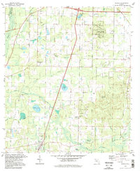
1994 Map of Wausau
USGS Topo · Published 1998About this map
Wausau serves as the primary settlement hub in this 1990s snapshot of the Florida Panhandle, where the landscape is defined by the convergence of numerous bays, branches, and ponds. The topography is marked by notable elevations such as Falling Waters Hill and Orange Hill, the former hosting the Falling Waters State Recreation Area complete with its Chipley Lookout Tower and campgrounds. This region in Washington County preserves a network of rural community landmarks, including Washington Ch, Shiloh Ch, and the Everett Cem. The drainage patterns are complex, with Hard Labor Creek and Holmes Creek winding through a terrain dotted with numerous claypits and several small water bodies like Gainer Lake and Owens Lake. The presence of Wausau Memorial Gardens and multiple rural churches reflects the long-standing social fabric of this timber and clay-rich countryside.
Find a feature on this map
51 named features on this map. Tap any name to fly to it.
Don’t see what you’re looking for? This feature index may not catch every label — zoom into the map to look around manually.
Map Details
Editions of this 1994 Wausau Map
This is the sole edition of this map. No revisions or reprints were ever made.
Other maps of this area

1950 · Vernon
USGS Topo · 1:24,000

1950 · Chipley
USGS Topo · 1:24,000

1950 · Wausau
USGS Topo · 1:24,000

1950 · Gap Lake
USGS Topo · 1:24,000

1950 · Poplar Head
USGS Topo · 1:24,000

1951 · Chipley
USGS Topo · 1:24,000

1951 · Wausau
USGS Topo · 1:24,000
1951 · Poplar Head
USGS Topo · 1:24,000

1951 · Bonifay
USGS Topo · 1:24,000

1951 · Gap Pond
USGS Topo · 1:24,000