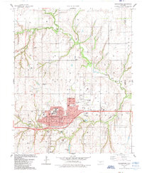
1985 Map of Weatherford
USGS Topo · Published 1985About this map
Southwestern State Univ serves as the focal point for the growth of Weatherford, Oklahoma, as documented in this mid-1980s topographical study. The city is a hub of education and transport, with the Farmrail line cutting through its southern edge and the Thomas P Stafford Airport positioned to the northeast. Beyond the campus, local life is traced through landmarks like Burcham Sch, East Side Sch, and the Drive-in Theater. The landscape transition from urban to rural is marked by extensive natural drainage including Deer Creek and Little Deep Creek. To the north, the terrain reveals an active energy landscape with numerous gas wells interspersed between historic sites such as Bradley Cem and the evocatively named Dead Women Crossing.
Find a feature on this map
26 named features on this map. Tap any name to fly to it.
Don’t see what you’re looking for? This feature index may not catch every label — zoom into the map to look around manually.
Map Details
Editions of this 1985 Weatherford Map
This is the sole edition of this map. No revisions or reprints were ever made.
Other maps of this area

1955 · Clinton
USGS Topo · 1:250,000

1956 · Cordell
USGS Topo · 1:62,500

1957 · Clinton
USGS Topo · 1:250,000

1957 · Clinton
USGS Topo · 1:62,500

1961 · Eakly
USGS Topo · 1:62,500

1964 · Weatherford
USGS Topo · 1:62,500

1976 · Clinton SE
USGS Topo · 1:24,000

1976 · Clinton NE
USGS Topo · 1:24,000
1983 · Corn
USGS Topo · 1:24,000
1983 · Indianapolis
USGS Topo · 1:24,000