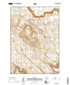
2020 Map of Weaver Lake
USGS Topo · Published 2020About this map
Sage Hen Valley and Scotts Canyon define the high desert topography of this region in Harney County. The landscape is marked by a network of seasonal water bodies and catchments essential for life in this arid environment, including Weaver Lake, One O'Clock Lake, and the curiously named West Batts Camp Lake. Man-made water management is evident through features like Cheatgrass Reservoir and Lookout Butte Reservoir, indicating the land's utility for livestock or local conservation. Transportation in this section of the Oregon outback relies on primitive routes such as Chain Lake Rd and the Beeshell Grade, which navigate the elevation changes between the flats and the canyon breaks. The map provides a detailed view of the township and range system across t24s r30e and surrounding sections, highlighting the sparse but vital landmarks that anchor this remote territory.
Find a feature on this map
18 named features on this map. Tap any name to fly to it.
Don’t see what you’re looking for? This feature index may not catch every label — zoom into the map to look around manually.
Map Details
Editions of this 2020 Weaver Lake Map
This is the sole edition of this map. No revisions or reprints were ever made.
Other maps of this area

1955 · Burns
USGS Topo · 1:250,000

1958 · Burns
USGS Topo · 1:250,000

1959 · Burns
USGS Topo · 1:250,000

1959 · Dog Mountain
USGS Topo · 1:62,500

1960 · Burns
USGS Topo · 1:62,500

1960 · Burns
USGS Topo · 1:24,000

1975 · Burns
USGS Topo · 1:24,000

1980 · Stinking Lake
USGS Topo · 1:24,000

1980 · Palomino Buttes
USGS Topo · 1:24,000

1981 · Sage Hen Hill
USGS Topo · 1:24,000