1945 Map of Webster
USGS Topo · Published 1945About this map
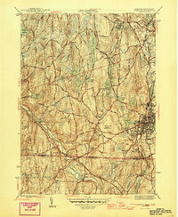
Industrial villages and mill ponds define the landscape of south-central Massachusetts and northern Connecticut at the end of World War II. The French River and Quinebaug River corridors are densely settled with manufacturing centers like North Village, Chaseville, and Wilsonville. This river-driven economy is supported by two major rail lines, the Boston and Albany Railroad and the New York New Haven and Hartford Railroad, which weave through the valleys to connect these manufacturing hubs.
Find a feature on this map
68 named features on this map. Tap any name to fly to it.
Don’t see what you’re looking for? This feature index may not catch every label — zoom into the map to look around manually.
Map Details
Editions of this 1945 Webster Map
2 editions found

Other maps of this area

1887 · Brookfield
USGS Topo · 1:62,500

1889 · Webster
USGS Topo · 1:62,500

1889 · Putnam
USGS Topo · 1:62,500

1890 · Brookfield
USGS Topo · 1:62,500

1892 · Woodstock
USGS Topo · 1:62,500

1892 · Webster
USGS Topo · 1:62,500

1893 · Putnam
USGS Topo · 1:62,500

1893 · Brookfield
USGS Topo · 1:62,500

1908 · Quinsigamond
USGS Topo · 1:125,000

1908 · Ware
USGS Topo · 1:125,000