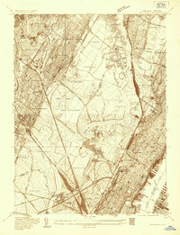
1935 Map of Weehawken
USGS Topo · Published 1935About this map
The Hackensack River and Hudson River define this 1935 industrial and residential landscape, where tidal marshes like Eight Day Swamp and Walden Swamp still occupy vast tracts between burgeoning boroughs. Significant institutional landmarks include the Hudson County Alms House Hospital and Penitentiary near Snake Hill and the Hudson County Hospital in Secaucus. The area is a dense network of early transit, showing the Erie RR and New York Central RR (West Shore) alongside developing corridors like State Hy No 6. Local history is captured in the numerous burial grounds such as Holy Cross Cem and Flower Hill Cem, as well as recreational sites like the Columbia Amusement Park in North Bergen. This survey provides a clear view of the complex infrastructure serving Weehawken, Hoboken, and the surrounding Bergen and Hudson County municipalities during the mid-1930s.
Find a feature on this map
77 named features on this map. Tap any name to fly to it.
Don’t see what you’re looking for? This feature index may not catch every label — zoom into the map to look around manually.
Map Details
Editions of this 1935 Weehawken Map
This is the sole edition of this map. No revisions or reprints were ever made.
Other maps of this area

1888 · Paterson
USGS Topo · 1:62,500

1889 · Brooklyn
USGS Topo · 1:62,500

1891 · Brooklyn
USGS Topo · 1:62,500

1891 · Harlem
USGS Topo · 1:62,500

1892 · Paterson
USGS Topo · 1:62,500

1897 · Harlem
USGS Topo · 1:62,500

1897 · Brooklyn
USGS Topo · 1:62,500

1898 · Harlem
USGS Topo · 1:62,500

1898 · Staten Island
USGS Topo · 1:62,500

1898 · Brooklyn
USGS Topo · 1:62,500